The geography of Nepal consists of nearly all types of climate within its small area of 147;181 sq km. It rises from less then 100 meters elevation in Terai to the northern rim of Gangetic Plain, beyond the perpetual snow line to some of the Earth's highest mountains. Nepal shares its boarders with India in East, West and South and with China in the North. This results the dependance of Nepal in India to access to the sea, the Bay of Bangal.
Nepal can be divided into three belts from South to North; Terai, Hill and Mountain Regions. The ever snow capped mountains are the source of ever flowing rivers of Nepal cutting the middle Hills.
Nepal can be divided into three belts from South to North; Terai, Hill and Mountain Regions. The ever snow capped mountains are the source of ever flowing rivers of Nepal cutting the middle Hills.
The Terai Region
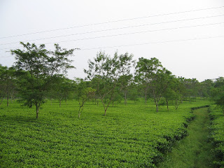
The Terai region generally named as Madhesh region starts from the Indian boarder and includes the southern part of Nepal. Its land structure is almost flat and is really fertile, so its Nick is "Store House of Nepal". Culturally, its an extension of Northern India and shares most of its festivals too. Hindi, Awadhi, Bhojpuri and Maithili are the spoken language of this region, which is more than Nepali speaking in that region. The Terai starts with intensively farmed gangetic plain named Outer Terai. The outer Terai ends with the first range of foothills called Siwalik or Churia, which has a densely forested area called the Bhabhar Prades, followed by the Siwaliks which rise upto 700 meters wit peaks as high as 1000 meters, steeper on the southern flanks. The Terai ends and the Hills begin relatively at the higher range called the Mahabharat Range.
The Hill Region
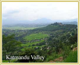
Above the bed of Terai region, there lies the beautiful range of hills(Pahar of Nepal). It ranges from 700 to 4,000 meters in altitude. This region begins from The Mahabharat Lekh which steeps southern sides which are mostly unhabited. Northern slopes are gentler and moderately habitated. North to this includes Nepali speaking Hindus and Newar merchants and the the valleys suited for rice cultivation as high as 2,000 meters. The growing city of the country, Kathmandu and Pokhara Valleys fall within this region. Maize, millet, barley and potatoes are the other staples here. temperate and subtropical fruits are favoured in this region.
The Mountain Range
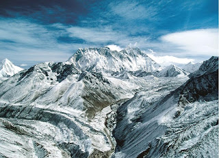
The Mountain Region rises into the zone of perpetual snow along the Main Central Thust fault zone. North of the Hills, the Himalayas rise as the virtual wall beyond the snowline at 5,000 to 5,500 meters to some 90 peaks over 7,000 meters and 8 exceeding 8,000 meters including The Mount Everest(Worlds tallest peak) at 8,848 meters and Kanchanjunga at 8,598 meters. Himalayas are not continuous across Nepal, unlike of the Hills. Alpine valleys including Humla, Jumla, Dolpa, Mustang and Khumbu lie between the Himalays, are lightly populated with Tibetian affinities called Bhotiya, among which the Sherpas in Kumbhu valley below Mount Everest. Bhotiya language and culture are found in this regiom upto the Tibet.
No comments:
Post a Comment